
Many Utah visitors are lured to the state’s better-known national parks such as Zion or Arches but visitors to Capitol Reef National Park are often blown away by the amazing geology and wide range of activities this lesser-known park has to offer.
Capitol Reef is an amazing wonderland of massive, multi-colored rock formations and dramatic slot canyons in a surprisingly green desert river valley. Early settlers to the region thought the Waterpocket Fold, a nearly 100-mile (161-kilometer) wrinkle in the Earth’s surface, looked like a “reef.” These pioneers also thought the huge white domes dotting the Waterpocket Fold looked just like the U.S. Capitol building so they named the area Capitol Reef.
There’s much more to do here than gaze at natural scenery. Capitol Reef is rich in Native American history and visitors can view petroglyphs and ancient sites throughout the park. Frontier settlers also left behind many artifacts of early life in the Fremont River Valley and visitors can tour the historic homesteads, orchards, and other artifacts left behind by these early settlers.
Capitol Reef National Park is located in south-central Utah – it’s the middle park of Utah’s five National Parks and is a bit harder to get to compared to the others. Capitol Reef is located 115 miles (185 kilometers) northeast of Bryce Canyon National Park and 130 miles (209 kilometers) southwest of Arches National Park.
Grand Junction Regional Airport is the closest major airport to Capitol Reef National Park. It’s located in Grand Junction, Colorado, about 196 miles (299 kilometers) east of the Capitol Reef National Park Visitor Center. Non-stop flights to Grand Junction are available from several major U.S. cities including Chicago, Denver, Phoenix, and Los Angeles.

The Salt Lake City International Airport is 229 miles (369 kilometers) north of Capitol Reef National Park and is serviced by most domestic and international destinations.

Some Capitol Reef visitors opt to fly into McCarran International Airport in Las Vegas, Nevada. Capitol Reef is 341 miles (549 kilometers) northeast of Las Vegas. Flying into Las Vegas may be a convenient option if you also plan to visit Grand Canyon, Zion, and/or Bryce Canyon National Parks.
Most visitors arrive at Capitol Reef National Park by car. There is no public transportation available in the park and a bit of driving is required to get to the popular park trailheads and viewpoints. Some park roads, including the spur roads to Grand Wash and Capitol Gorge and the road to Goosenecks Overlook, are unpaved. These roads are typically suitable for passenger cars and RVs up to 27 feet (8.2 meters) in length but may be impassable when wet.

Entrance fees are only required in Capitol Reef National Park if you drive beyond the Fruita Campground on the park’s scenic drive. Passes are valid for seven days and the fee is the lowest of all the Utah National Parks. If you plan to visit other national parks in a year timeframe, it may make more sense to purchase an annual parks pass, which provides entry to all the national parks as well as hundreds of other recreation areas.
The Fruita Campground is the only developed campground in the park. This 71-site campground is surrounded by the historic Fruita orchards and several trails, including the Cohab Canyon Trail and Fremont River Trail, are easily accessed right from camp. Campsites are reservable from March 1 through October 31 and reservations can be made up to six months in advance. All campsites are first-come, first-served for the rest of the year.

The small town of Torrey, Utah, is located just 15 minutes west of the park’s visitor center and offers a huge variety of lodging options including RV parks, glamping resorts, hotels, and vacation rentals. You’ll find everything from tiny cabin rentals and decked-out authentic Conestoga Wagons to bed and breakfasts and luxury desert retreats. You can also find additional lodging options in the neighboring communities of Teasdale, Bicknell, and Caineville.
Capitol Reef National Park is surrounded on all sides by Bureau of Land Management (BLM) lands and national forest. Unlimited opportunities exist for dispersed camping, meaning camping outside of a designated campground. Some areas even offer restrooms and other facilities. There are also several national forest campgrounds located on Boulder Mountain. These campgrounds can provide a more comfortable camping experience in the heat of summer considering the higher elevation and cooler temperatures.

Spring and fall are the best times to visit Capitol Reef National Park. Temperatures are typically pleasant during these times and you avoid the summer crowds. The orchards are typically in bloom from late March through mid-April and wildflowers tend to be the best from late April through early June.
Monsoons are frequent in July and August necessitating some trail and road closures due to flash flood risks. Multi-colored fall leaves are especially gorgeous when surrounded by Capitol Reef’s red rock cliffs and fall colors often peak in mid-October. Winter is also a wonderful time to visit Capitol Reef but some roads and trails may close due to snow and ice.

Capitol Reef is often overlooked by visitors. Many visitors simply pass through and take in a few of the scenic viewpoints on their way between Bryce Canyon and Arches National Parks. Stay for a day or two and there’s a good chance Capitol Reef will end up being one of your favorites.
The Fruita area of Capitol Reef National Park is quite compact, so it is easy to see a lot in a short amount of time. If you only have one day, drive the park’s scenic drive and venture down both the Grand Wash and Capitol Gorge spur roads. With one day, you’ll also have time to tour the Gifford Homestead, wander amongst the orchards, and do the short hike to Hickman Bridge.

Although Capitol Reef National Park does not see the same levels of crowds as Zion, Bryce Canyon, and Arches National Parks, the park does get busy during the summer months and on spring and fall weekends.

Early settlers to the area planted fruit trees along the Fremont River and Sulphur Creek for both subsistence and as a cash crop. Apples, cherries, apricots, pears, peaches, and plums thrived here so the community changed its name from Junction to Fruita in the early 1900s. The National Park Service, using the same heritage techniques as the original pioneers, maintains the orchards and visitors are free to tour the orchards and pick fruit.

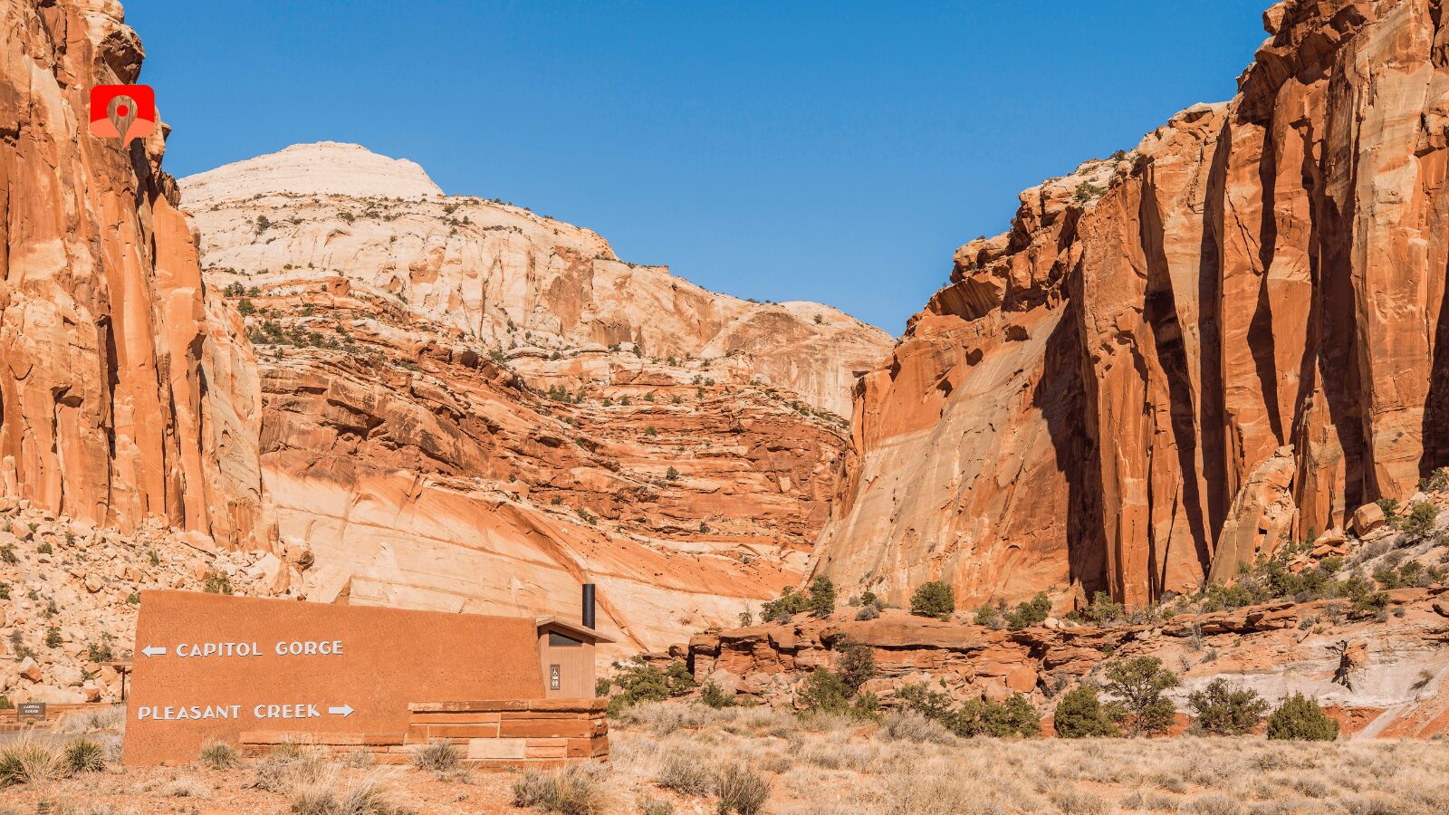
The Capitol Reef Scenic Drive is a 7.9-mile (12.7-kilometer) paved road that winds through the heart of the park. The drive begins at the visitors center and provides access to the campground and numerous trailheads. The dirt spur road into Grand Wash, a huge walled canyon, is a definite must-do if you’re traveling in a vehicle under 27 feet (8.2 meters) in length. This twisting dirt road ends after only a mile (1.6 kilometers) at the trailhead for Cassidy Arch and the hiking trail that follows Grand Wash to its junction with Highway 24.

The official scenic drive ends at the end of the pavement but an unpaved spur road continues for two miles (3.2 kilometers) into Capitol Gorge. It’s hard to believe that this narrow, twisting roadway used to be the main throughway through this part of south central Utah. At the end of the road, you can hike along the old roadbed to the Pioneer Registry, a spot where early pioneers and Mormon settlers carved their names in the rocks as they passed through the canyon.

Native people of the Fremont Culture made their home in Capitol Reef National Park well before the first pioneer settlers. They left their mark on Wingate sandstone cliffs throughout the park. One of the easiest places to see these petroglyphs, ancient images carved into stone, is along Highway 24, just 1.1 miles (1.7 kilometers) east of the visitor center. Here, two boardwalk paths provide views of these human-like carvings, as well as other animals and geometric symbols. For a closer look, bring binoculars.

Built in 1896 for the handful of school-aged children living in Fruita, the one-room Fruita Schoolhouse remained a functional grade school until a lack of students closed it in 1941. The Fruita Schoolhouse stands in its original location and visitors can peer through the windows and imagine what school life was like in such a remote place.

This is one of the best short hikes in Capitol Reef. It’s only one mile (1.6 kilometers) from the parking area to Hickman Bridge, a huge natural arch. The trail meanders along the Fremont River before climbing up the lower slopes of the Waterpocket Fold to Hickman Bridge.

Named after the famous outlaw, Butch Cassidy, who used to hide out in the labyrinth of canyons in Capitol Reef, Cassidy Arch is a massive natural arch that sits high above Grand Wash. It’s only 1.75 miles (2.8 kilometers) to the arch from the Grand Wash Trailhead but the climb is steep and very much worth it. Cassidy Arch is incredibly photogenic from almost every angle and you can literally walk across the top of the arch.

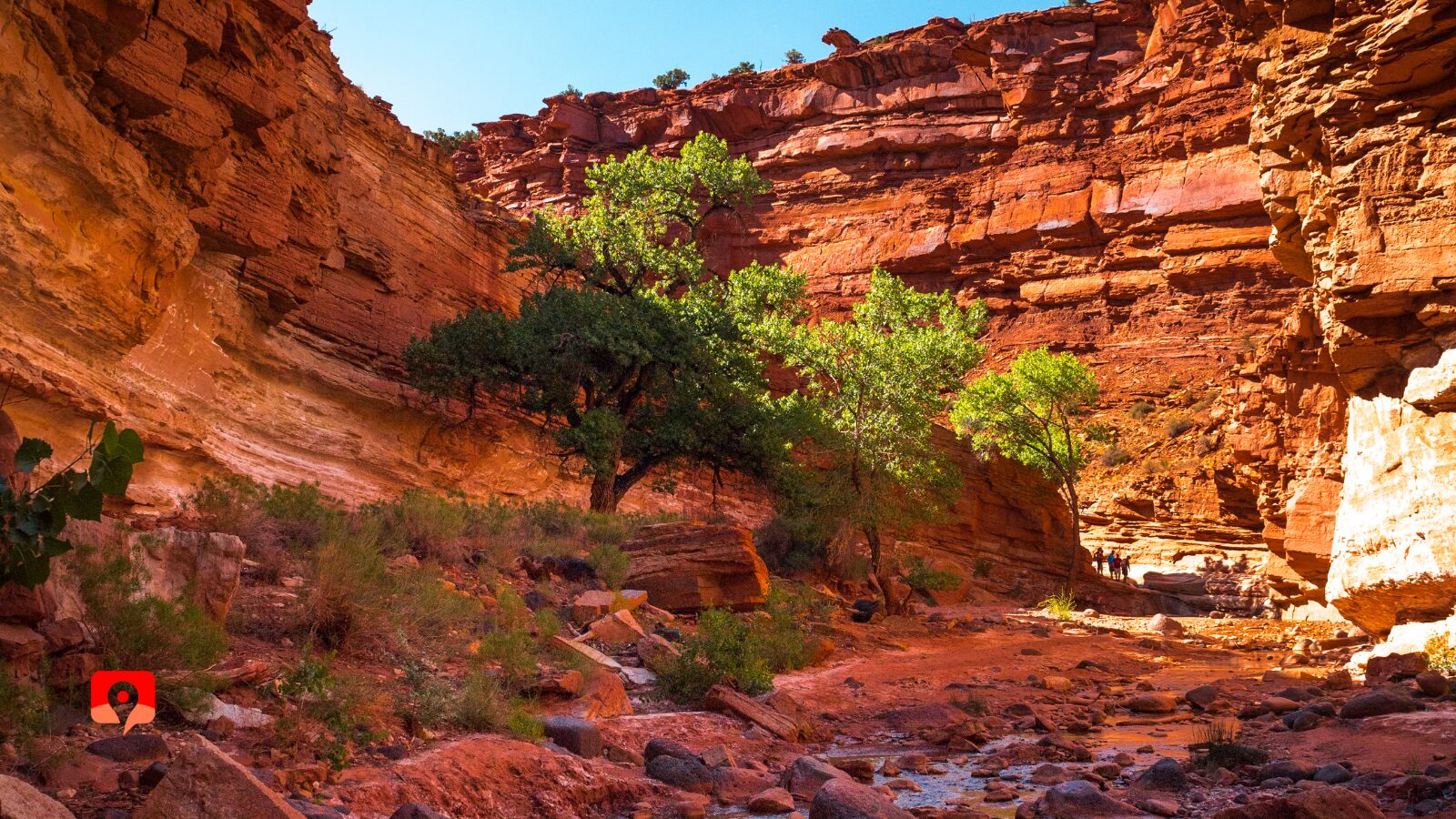
This easy, family-friend hike follows a dry, sandy creek bed for 2.3 miles (3.6 kilometers) one-way with towering cliffs on each side. At its narrowest point, the cliff walls are only 15 feet (4.6 meters) apart. There are two ways to access the Grand Wash Trail – from the end of the Grand Wash spur road or the trailhead on Highway 24. The trail can easily be done as an out-and-back or you can take the trail one-way with a car or bike shuttle.
The Capitol Gorge hike begins from the parking area at the end of the Capitol Gorge spur road. In only a mile (1.6 kilometers) the trail passes by numerous petroglyph panels and the historic signatures carved at the Pioneer Registry. You can make the hike longer by continuing onto the Tanks, pockets in the sandstone often filled with water, or following Capitol Gorge all the way to the park boundary and an interesting abandoned old car.

Located near the west entrance of Capitol Reef National Park, the Chimney Rock Trail is a 3.6-mile (5.8-kilometer) loop with spectacular panoramic views of the Waterpocket Fold and the distant Henry Mountains. The trail passes by its namesake, Chimney Rock, an eroded tower of red rock, and climbs nearly 600 feet (183 meters) to the trail’s highest viewpoint.

Located one mile (1.6 kilometers) south of the visitor center along the park’s scenic drive, the historic Gifford Homestead is a monument to the park’s pioneer history. The Gifford Family occupied the home from 1928 until they sold it to the National Park Service in 1969.
Today, visitors can tour the homestead, sample freshly baked pie, and browse handmade items made by local craftsmen at the Gifford House. The Gifford House opens for the season on Pi Day (March 14) and closes at the end of October. Pies often sell out early in the day so make sure to get there first thing in the morning.
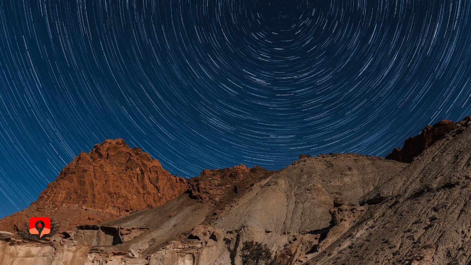
Capitol Reef National Park is designated an International Dark Sky Park. Capitol Reef has some of the best night sky viewing in the entire U.S. In fact, the neighboring town of Torrey is one of the few designated International Dark Sky Communities in the U.S.
The Capitol Reef area is so free from light pollution, you can easily view the Milky Way with your naked eye. Ranger-led dark sky tours are offered monthly and the Annual Heritage Starfest takes place each September around the new moon. Dark sky tours and star parties are also offered by outfitters in Torrey.
Canyoneering is an exciting way to explore the rugged canyons of Capitol Reef National Park. Canyoneering involves using ropes and other climbing techniques to travel through steep and narrow canyons. Experienced canyoneers must obtain a free permit at the visitor center and several area outfitters offer guided canyoneering tours in the park of various difficulties and experience levels.
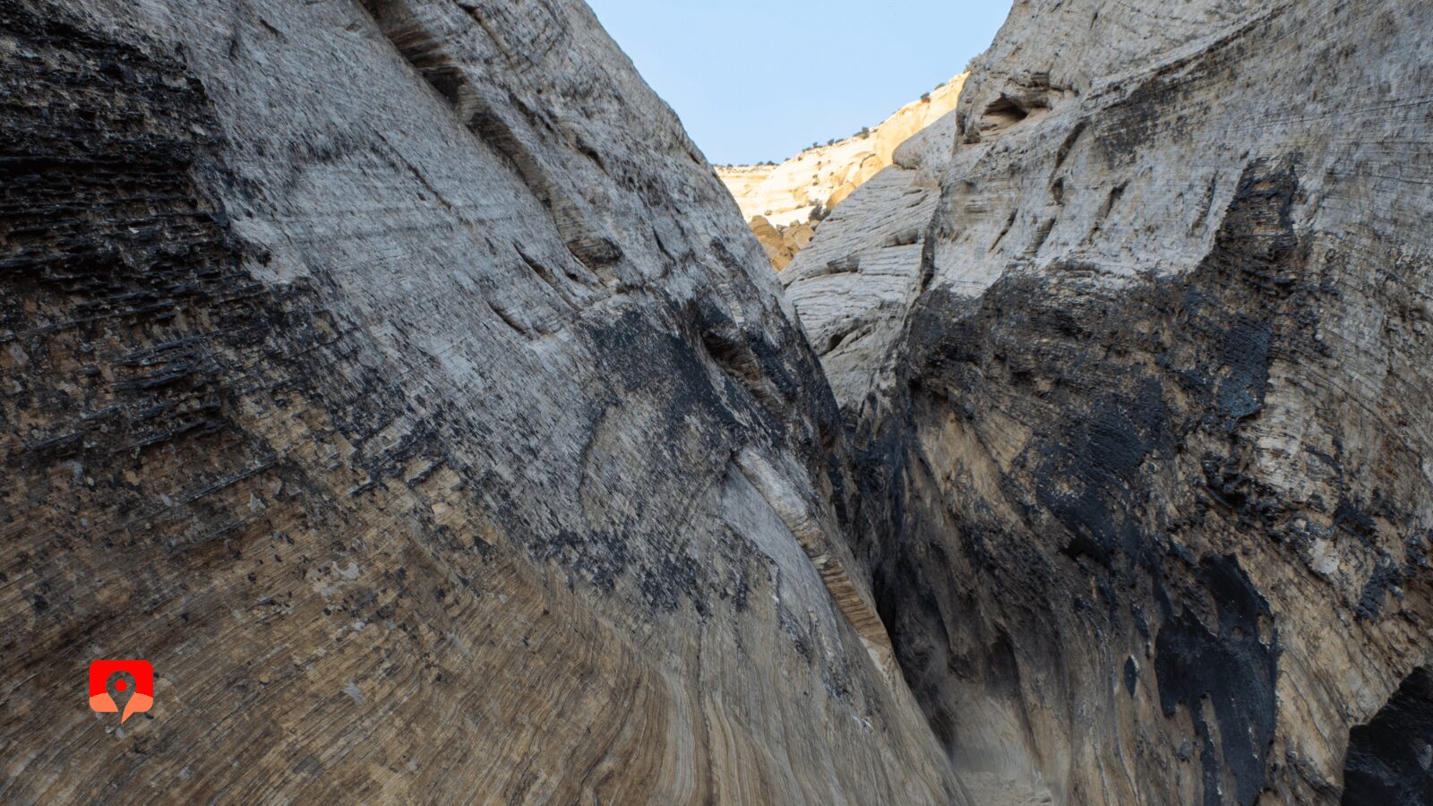
Sulphur Creek is not an official park trail, rather it’s an unmaintained route through a deep and narrow canyon. The hike involves walking through shallow water and navigating rock obstacles. Many hikers choose to hike the entire route from the trailhead near the Chimney Rock Trailhead, on Highway 24, while others simply hike upstream from the visitors center to the first waterfall to cool off on hot days.

Located in the rugged southern section of the park, the Waterpocket District is only accessible by unpaved roads. Visitors looking to experience a bit of the park’s more remote scenery, can drive a 124-mile (199-kilometer) loop through this lesser-visited region of the park – it’s called “Looping-the-Fold.”
The loop starts at the visitor center and then travels on the Notom-Bullfrog Road, the Burr Trail Road, and then on Highway 12 back to Torrey. Most passenger cars can drive the route with very little difficulty but it’s a good idea to check in at the visitor center for current road conditions. There are many opportunities for hiking and sightseeing along the way.

The aptly named Sunset Point is one of the best spots to enjoy the sunset at Capitol Reef National Park. The short hike, just 0.8 miles (1.3 kilometers) roundtrip, to the viewpoint offers fantastic views of the Waterpocket Fold and is the place to be at sunset.

The very short Goosenecks Trail starts from the same trailhead as Sunset Point and offers great views of the windy path Sulphur Creek carved into the rocks below. The overlook is especially beautiful at sunset. Just be sure to keep a close eye on kids, there are plenty of steep drop-offs and few guardrails.

Extra Layers: The southern Utah desert is known for its extremes. Temperatures can fluctuate widely between the day and night and higher elevations will be much cooler. It’s best to come prepared for scorching daytime temperatures and chilly nights, and always be prepared for rain, even though it is a desert.
Water Shoes: If you’re planning on doing the Sulphur Creek hike, bring some hiking shoes you don’t mind getting wet or hiking sandals.
Trekking Poles: Many of the trails in Capitol Reef National Park involve hiking over rocky and uneven ground. Trekking poles can provide extra stability when hiking over rugged terrain and are especially helpful when hiking through Sulphur Creek.
Sun Protection: Pack sunscreen, lip balm, sunglasses, and a wide-brimmed hat to protect yourself from the harsh desert sun.
Daypack: If you plan to do any hiking, you’ll want a comfortable daypack with lots of pockets. This will keep everything you need such as water bottles, sunscreen, snacks, and trail maps conveniently with you at all times.
Refillable Water Bottle: Always carry more water than you think you’ll need in the desert. Bring along several refillable water bottles or a hydration bladder to keep you hydrated during hot days in the desert.
Cooler: Bring along a small cooler packed with ice, drinks, and snacks. Not much is better than enjoying a cold drink after a hike in the desert. A cooler is also important for keeping your Gifford House Pie fresh to enjoy after your hike.
Plastic Bag: We always carry a plastic bag when we hike, so we can do our part and help keep the trails and waterways clean. If you see some trash along the way, pick it up, drop it in the bag. When you get back to the trailhead, simply drop your bag in the recycling or trash bin and voila! You’ve helped keep the parks beautiful for everyone who visits.
